ИСТОЧНИК
ВСЕХ СОЛНЦ - ЭТО ПУЛЬТ УПРАВЛЕНИЯ МУЛЬТИВСЕЛЕННОЙ !
SOURCE
OF ALL SUNS - IS A CONTROL PANEL OF THE WHOLE MULTIVERSE !
РАЗЖИЖЖАЮЩАЯСЯ
ПЛАНЕТА - MELTING EARTH
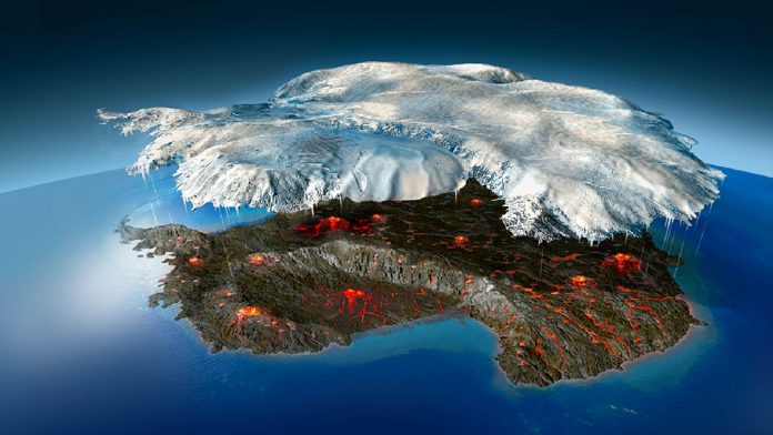
Вулканы Антарктиды
!
ANNOUNCEMENT:
This page has been modified to be viewable on Mobile devices
Важное Сообщение -
эта Страница теперь может быть просмотрена на
мобильных телефонах!
ДОМАШНЯЯ
СТРАНИЦА - HOME PAGE
 Грязевые вулканы
начинают умертвлять города. Грязевой
вулкан поглотил много деревней в Индонезии
Грязевые вулканы
начинают умертвлять города. Грязевой
вулкан поглотил много деревней в Индонезии
Mud Volcanos started ruining cities
of Earth, mud buried many villages in Indonesia

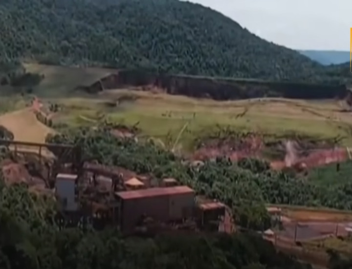
(Грязевой
вулкан поглотил много деревней в Индонезии) Did an Australian linked
mining firm trigger a natural disaster? (mud buried many villages), 17
января 2023
https://www.youtube.com/watch?v=M7rd_HwLa9w
EARTH'S CRUST WAVES - ЗЕМЛЯНЫЕ ВОЛНЫ
This extract is about EARTH'S CRUST WAVES,
"Far Journeys" by Robert Monroe, p. 87 :
"I smoothed at
the desk clerk. (Sorry, I didn’t know it was
a private space.)
The desk clerk
vibrated. (What
other kind
is there!)
I flickered. (You mean all of
these buildings are
private?)
The desk clerk dulled.
(Then what are all these
people doing here? There must be a
hundred!) I hit it strong enough to catch his attention.
(It's
their private space,
naturally.)
(All one hundred?)
The desk clerk waved me over
to the desk and I followed. He
pointed to the drawing on the wall behind him. It showed some five rows
of large black dots, that
looked like holes, twenty to a row.
(That's
our personal space.) He gestured
proudly. (Best in the city.)
I stared at the drawing. (You
go into
those?)
He nodded.
(Only when the surge takes
place. They’re this big across the middle.) He
indicated a width of about two feet with his arms. He was about to
continue, when there was a sound like thunder
in the distance and the floor began to rock. Immediately, everyone in
the room turned and hurried
out through exits in the back. The room clerk ran to join them.
(That's the surge starting up,) he
called over his shoulder. (I suppose that's
what you came to witness, but you
better get to your personal space fast.)
Then the room was empty and I
tried to keep my footing as
the floor heaved rhythmically. I staggered over to the entrance as the
roar grew louder. In the distance and approaching fast was a mighty
wave, not water, but in the ground itself, lifting buildings and
streets into a tumbling flotsam
hundreds of feet high. Behind the first wave, I could see a second and
a third wave, each larger
than the first. There may have been more, but I didn't have a chance to
find out, as the first wave
came surging into where I was, and the building lifted and tumbled, me
in it, bouncing, rolling,
twisting, jarring . . .desperately, I tried to focus, ident what? ident
. . . ident Z-55/LOU . . . reach and stretch . . . closed
tightly..."
Video - EARTH'S CRUST WAVES - ЗЕМЛЯНЫЕ ВОЛНЫ
(recommended watch)
https://www.youtube.com/watch?v=sQBb5fzSsD4
Этот
отрывок о ЗЕМЛЯНЫЕ ВОЛНАХ
из книги "Далёкие Путешествия" Роберта Монро я перевела на русский,
стр. 87 :
"У стола я извинился: "Извините я не знал, что это частное владение."
Служитель у стола заволновался:"А какое ещё может быть?"
Я всё ещё сомневался:"Вы имеете ввиду, что все эти здания - частные
владения?"
Служитель потерял интерес.
"Тогда, что все эти люди делают здесь? Их должно быть сотня!" Я напирал
довольно решительно, чтобы привлечь его внимание.
"Естественно, ведь это их частное владение."
"Всей сотни?"
Служитель
за столом поманил меня к столу и я последовал. Он указал на чертёж на
стене сзади него. Чертёж показывал пять рядов больших чёрных точек,
которые выглядели как дыры, 20 дыр в каждом ряду.
"Это наше личное место." Он гордо жестикулировал. "Лучшее в городе!"
Я уставился на чертёж:"И вы в них помещаетесь?"
Он
кивнул:"Только когда Волна надвигается. Они вот такие большие
посередине." Он своей рукой показал их ширину: около 2х футов. Он было
хотел продолжить, как вдруг вдали раздался гром и пол начал качаться.
Тут же все в комнате повернулись и поспешили выскочить через задний
выход. Служитель выскочил за ними:"Это начинается Волна!" закричал он
через плечо. "Полагаю, что это то, для чего вы прибыли, чтобы быть
свидетелем, но сейчас вам лучше спрятываться в ваше личное место и
побыстрей."
Затем комната опустела, а я пытался сохранять
равновесие, так как пол ритмично трясся. Я продвигался ближе к выходу
по мере того, как рёв усиливался. Вдалеке быстро приближалась
огромнейшая Волна, не воды, а самой Земли, поднимая здания и улицы,
собирая их в
катящийся Ком всего разломанного по пути, высотой в сотни футов. За
первой Волной я видел вторую и третью, каждая из них - больше первой.
Наверно было больше, но у меня не было возможности выяснить, так как
первая Волна подошла туда, где я находился, и здание подняло, оно
покатилось со мной внутри, подпрыгивая, извиваясь, разламываясь с диким
грохотом ...с отчаянием я старался сфокусироваться, пароль Z-55/LOU
...достичь и вытянуться..."
Видео: Отметили Рождество в
Чили. Dec 28, 2020
(с 21 минуты в течении 40
секунд виден поток энергии
Неорганических Существ, поток, входящий внутрь земли. ЛМ)
https://www.youtube.com/watch?v=C4qQrcXLNOc
Облако
над вулканом Кальбуко (Чили). 4 февраля 2021
https://zen.yandex.ru/media/princesa/oblako-nad-kalbuko-601b12d4571f7906b2fa59d9
Вчера
муж пришел с работы и рассказал, что все обсуждают новость. Жители
города Пуэрто-Монта и окрестностей обеспокоились видом вулкана
Кальбуко. Над ним что-то клубилось, и казалось, белый дым выходил из
его жерла, поднимаясь высоко в небо. Начали предполагать, что проснулся
вулкан, тем более несколько лет назад уже было извержение вулкана
Кальбуко. Это случилось 22 апреля 2015 года. Извержение было видно из
дома моего мужа, Извержение вулкана Кальбуко, фото, которое Марко
сделал из дома. Тогда весь пепел ушел в Аргентину, накрыв значительную
территорию, ветер дул в сторону Анд. Чилийцы до сих пор шутят,
вспоминая то событие, ведь от Кальбуко пострадала только Аргентина, а
не Чили, где расположен вулкан. На острове Кальбуко тоже не было пепла.
Но вчера, присмотревшись получше, жители поняли, что вулкан и не
собирался извергаться, просто над ним зависло облако необычной формы.
Облако улетело, все успокоились, и шутили над этой ситуацией. Вечером
Марко работал в море, взглянул на вулкан Кальбуко, и увидел, что над
ним снова зависло облако причудливой формы, похожей на дым из жерла. Он
сделал фото, но сказал, что в этот раз облако было уже не такое
большое, как в предыдущий. Интересно, почему эти облака стали
появляться именно над Кальбуко, а не другим вулканом? Я тоже на днях
заметила, что над Андами стали появляться кучевые облака, что здесь
редкость. Сейчас лето, время появления кучевых облаков, иногда они
могут приобретать такую необычную форму и смущать жителей, ведь мы
живем в окружении Анд и вулканов. Кучевые облака над Андами. Их здесь
так много, что у нас на острове даже улицы названы в честь разных
вулканов.
Рассказ
дедушки и бабушки моего чилийского мужа о землетрясении 1960 года
(Чили). 16 October 2020
(это то, что нужно ожидать в скором будущем)
 Красным обозначены
исчезнувшие районы города в результате Земляных Волн на поверхности !
Красным обозначены
исчезнувшие районы города в результате Земляных Волн на поверхности !
Меня
зовут Ксения, я живу в Чили на южном острове Кальбуко с мужем Марко.
Гуляя по городу Пуэрто Монт мы увидели старый дом с открытой дверью, на
которой была табличка, что в этом помещении проводится выставка
фотографий Великого чилийского землетрясения, чилийцы его называют
"Землетрясение в Вальдивии". Это было самое сильное землетрясение в
истории наблюдений на нашей планете. На входе никого не было, как и
внутри. Я удивилась тому, что никто эту выставку не охраняет, зайти и
бесплатно посмотреть может каждый желающий, что мы и сделали. Мы зашли
и огляделись – вокруг на стенах развешаны фотографии, где
запечатлены
разрушения в городе Пуэрто Монт и других наиболее пострадавших от
землетрясения и цунами. У входа лежала книга, куда каждый мог записать
впечатления. Я покажу вам эти фото, а также расскажу то, что мне
поведали очевидцы тех событий – бабушка и дедушка Марко.
Великое
Чилийское Землетрясение. Случилось это 22 мая 1960 г. Было 3 часа дня.
Дедушка мужа Белармино жил вблизи города Льянкиуэ.
В это время он
работал. Внезапно началось
землетрясение и Белармино сказал, что земля
начала двигаться БОЛЬШИМИ ВОЛНАМИ КАК МОРЕ. Устоять на ногах
было
невозможно. Он ухватился за столб забора. В то же время
бабушка мужа
Мария находилась на острове недалеко от нашего острова Кальбуко, она
там жила с родителями. Мария рассказывает, что когда началось
землетрясение, она была в доме, чудесным образом он уцелел и все
остались живы. Она, как и Белармино, находящийся на континенте, слышала
звуки будто громкие выстрелы. Когда все только начиналось, жители
островов
увидели, что океан ушел и обнажилось дно. Такого сильного
отлива никогда не было. Некоторые пошли к берегу
посмотреть. Перед ними
открылась такая картина:
океанское
дно без воды и подпрыгивающие рыбы,
которые не успели уплыть – так быстро ушла вода. Когда
началось
землетрясение, люди видели, как одни острова опускаются под воду,
другие появляются из океанской пучины, они двигались и
переворачивались, многие острова с растущими на них лесами навсегда
скрывались под водой. Тогда-то люди услышали звуки выстрелов, исходили
они от рушащихся скал – острова здесь представляют их
верхушки,
торчащие из воды. На континенте Белармино слышал такие же звуки
выстрелов – это рушились и уходили под землю горы. Он сказал
также, что
земля разрывалась на части, образуя разломы, в которые падали дома,
машины, животные, и потом разлом снова соединялся, и так продолжалось
все время землетрясения – земля открывалась и закрывалась,
поглощая и
перемалывая и живое, и неживое. Землетрясение
продолжалось 15 минут.
Магнитуду записали как 9.5- 9.6 и более, потому что в то время в Чили
прибор, показывающий магнитуду имел именно это максимальное значение,
но говорят, что иголка засекла толчок намного больше, чем 9.6. Поэтому,
какова была реальная магнитуда уже никто не узнает, но чилийцы говорят,
что она была больше, чем указано в средствах массовой информации. То же
самое и с числом погибших – их намного больше, чем 5700 что
указаны в
официальных источниках, ведь в те времена у многих чилийцев даже не
было паспортов (карнет), они не спешили их получать, и такие люди не
вошли в списки. Дедушке мужа, например, карнет выдали только в 13 лет.
Цунами. После землетрясения пришло цунами и накрыло город Вальдивию,
другие прибрежные населенные пункты и многие острова. В некоторых
местах волны цунами доходили высотой до 25 метров. Бабушка рассказала
что на ее острове никто не погиб, потому что вода, после того как
произошел тот сильный отлив, с приходом цунами начала подниматься, но
медленно, затапливая дома. Люди успели подняться в гору и спастись.
Затопление. После цунами оставшихся в живых жителей Вальдивии постигла
другая беда – во время землетрясения отломилась часть гор
Анд, упала и
перекрыла реку у озера Riñihue. Высота воды в озере
поднялась на 20
метров, Вальдивию и близлежащие населенные пункты затопило. Селения
были полностью затоплены, а чтобы спасти Вальдивию люди начали рыть
большой ров, новое русло, по которому планировали пустить реку из
затопленного города, таким образом осушить территорию. Но тут произошла
новая беда. Пошел дождь, да такой, какого никогда в истории не было,
этот дождь чилийцы сравнивают с потопом Ноя. Он шел без остановки день
и ночь все то время, пока люди рыли лопатами ров. Использовать технику
и экскаваторы не могли по причине дождя и размокшей после цунами земли,
превратившейся в грязь, которая все засасывала в свою трясину. Tакже не
стихали афтершоки, во время которых люди увязали в этой грязи. Пока
рыли, находили в толще грязи погибших людей и животных. Работы
продолжались чуть больше двух месяцев, дождь шел все это время. 27 июля
добились того, что вода потекла по вырытому руслу. Тонны воды двинулись
с сильным шумом, расширяя и углубляя своим потоком созданное русло.
Зимой идут дети босиком по грязи, с ними
женщина в обуви. Дети здесь более холодостойкие, чем взрослые. Примечательно, что в 1575 году в
этих же местах уже происходило землетрясение, и река в том же месте
была перекрыта упавшей скалой. Но Вальдивия в те времена была еще
небольшим городом, воды реки обрушились на город и близлежащие селения
и унесли жителей и их дома в океан, погибли тысячи человек. После
землетрясения и афтершоков, пришедших вскоре, примерно неделю спустя
люди только начали узнавать новости, передвигаться, исследовать
территорию, обнаруживая, что привычный ландшафт изменился, некоторые
горы исчезли. Кто-то из родственников дедушки работал у
немцев и
от них узнавал информацию о произошедшем раньше, чем другие жители, и
рассказывал Белармино. Бабушка и дедушка говорят, что афтершоки
продолжались еще полгода. Во время землетрясения сильно изменился
ландшафт, сейчас на карте видны множественные озера от Вальдивии ближе
к Андам, говорят, раньше многих из них не существовало. Земля
опустилась, и после затоплений и всех катаклизмов образовались эти
озера. На своем канале я вам показывала видео Вальдивии, сейчас там на
месте гор равнина, также была изменена береговая линия –
что-то ушло
под воду. К сожалению не удалось найти фото до землетрясения для
сравнения – раньше не было спутниковых снимков. Во время
землетрясения
Анды рушились, переворачивались и падали, из-за этого леса сдвинулись в
сторону на более 500 метров от того места, где росли. Некоторые деревья
остались на своих местах, но упавшие и переломанные. Чилийцы до сих пор
помнят то землетрясение, по телевизору я видела передачи про это,
рассказы очевидцев. Необычное чувство, я живу не очень далеко от
эпицентра событий и понимаю, что тишина и спокойствие этих мест
обманчиво. Муж мне говорит, что хорошо, если происходят небольшие
землетрясения, а вот когда совсем нет землетрясений - это плохой знак,
ведь под землей накапливается напряжение, которое в один момент может
привести к неожиданным последствиям. Я надеюсь, что подобного
Вальдивскому землетрясению никогда больше не произойдет.
From
Wikipedia: "Wrecked houses in Valdivia, Chile. Approximately 1,655
people were killed during the largest earthquake ever recorded.
Thousands more were injured, and millions were left homeless. The quake
triggered a tsunami that killed 61 people in Hawaii, 138 in Japan and
32 in the Philippines. The earthquake ruptured where the Nazca Plate
dives underneath the South American Plate, on the Peru-Chile Trench."
Почему Антарктида трясется как
сумасшедшая? Более 50 000 землетрясений за 3 месяца ставят ученых в
тупик. 18 Dec. 2021
https://earth-chronicles.ru/news/2020-12-18-146835
Прыгающие
фанаты произвели землетрясение (эта
статья прекрасно
объясняет бунты, протесты и драки в нестабильном Сиэтле! ЛМ)
http://www.gismeteo.ru/news/sobytiya/7488-prygayuschie-fanaty-proizveli-zemletryasenie-magnitudoy-2/
4 декабря 2013
Вечером
в минувший понедельник в Сиэтле (США) встречались две футбольные
команды — местные «Сиэтл Сихокс» и
«Нью-Орлеан Сэйнтс». Команда хозяев
одержала победу со счетом 34:7. Эта встреча примечательна тем, что
прыгающие от радости болельщики «Сихокс» стали
причиной
землетрясения... Вибрацию, похожую на подземные толчки, зарегистрировал
сейсмометр Вашингонского университета, установленный в одном квартале
от футбольного поля...Ранее мы сообщали о том, что в Сиэтле может
произойти землетрясение магнитудой 7,0, которое может стать причиной
смертоносных оползней в мегаполисе. В южной части центра Сиэтла
проходит разлом, по линии которого и может произойти крупное
землетрясение. Если землетрясение случится зимой, в зоне схода оползней
окажутся 8 тысяч зданий. При засушливых погодных условиях в зоне риска
окажется 1 тысяча зданий. Сиэтлский разлом, длина которого составляет
48 километров, проходит под системой заливов Пьюджет-Саунд, под центром
Сиэтла и под островом Бейнбридж. Последнее крупное землетрясение по
линии этого разлома датируется 900 годом н.э...
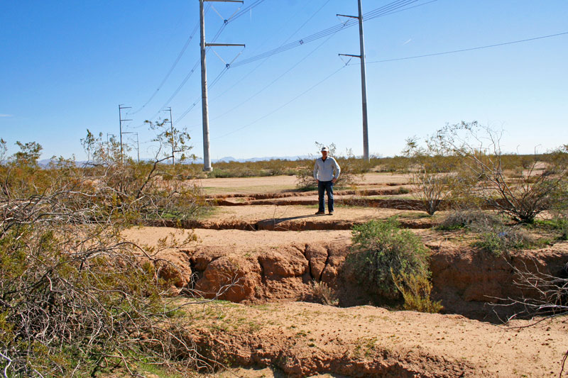
Гигантские трещины покрывают пустыню в Аризоне.
https://earth-chronicles.ru/news/2021-03-23-149495
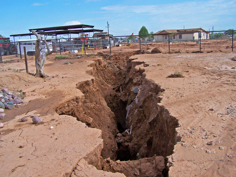
U.S. 89 Arizona Highway Collapse Explanation. Large fissures threaten
homes and businesses in Arizona
https://www.youtube.com/watch?v=El9zXXpZtCU
https://www.youtube.com/watch?v=lXVJy8jgg4I
https://www.youtube.com/watch?v=aA_O6lGKKnI
https://www.youtube.com/watch?v=VmG4UvCHuHw
https://www.youtube.com/watch?v=JVVjXrEPlq0
КРОМЕ
НАВОДНЕНИЙ, ОПОЛЗНЕЙ И ДЫР В ЗЕМЛЕ, ВУЛКАНЫ ТОЖЕ СПОСОБСТВУЮТ
РАЗЖИЖЖЕНИЮ ПЛАНЕТЫ !
APART FROM FLOODS,
LANDSLIDES, AVALANCHES, CRACKS AND SINKHOLES, VOLCANOS CONTRIBUTE TO
MELTING OF OUR PLANET !
Icelandic volcano erupts near
Reykjavik. Mar 20, 2021
https://www.bbc.com/news/world-europe-56465393
A
volcano has erupted south-west of Iceland's capital Reykjavik, the
country's meteorological office says. It says the fissure is about
500-700 metres long (1,640-2,300ft) at Fagradalsfjall on
Reykjanes peninsula. The last eruption there was some 800 years ago.
Iceland has recorded more than 40,000 earthquakes in the past three
weeks. In 2010, the eruption of another volcano, Eyjafjallajokull,
brought air traffic to a halt across Europe...
Рядом с Рейкьявиком начал извергаться вулкан Фаградальсфьядль. Mar 20,
2021
https://www.bbc.com/russian/news-56444272
Фаградалсфьяль
находится примерно в 30 км к юго-западу от Рейкьявика. Извержение
вулкана Фаградальсфьядль началось на юго-западе Исландии недалеко от
столицы страны в пятницу после тысяч небольших землетрясений в этом
районе за последние недели. "Я вижу светящееся красное небо из своего
окна", - сказала жительница города Гриндавик, находящегося в 8 км от
вулкана. "Здесь все садятся в машины, чтобы подъехать туда".
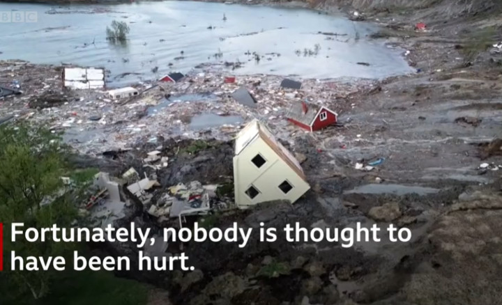
Norway landslide: Houses buried in Gjerdrum village near Oslo. 31
December 2020 - article and video
https://www.bbc.com/news/world-europe-55484627
Quick clay landslides in Norway (and Sweden)
https://www.ngi.no/eng/Services/Technical-expertise/Quick-clay-landslides/Quick-clay-slides-in-Norway

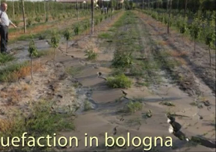
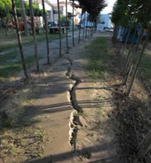
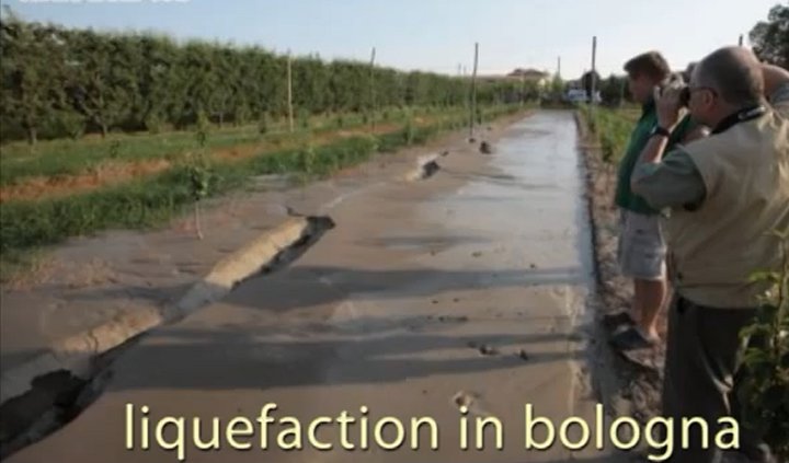 ТРЕЩИНЫ
И РАЗЖИЖЖЕНИЕ ПОЧВЫ В БОЛОНЬЕ, ИТАЛИЯ
ТРЕЩИНЫ
И РАЗЖИЖЖЕНИЕ ПОЧВЫ В БОЛОНЬЕ, ИТАЛИЯ
Воронки в земле: в центре Хорватии
появилось более 100 провалов. Странные дыры поглощают Хорватию. Mar 5,
2021
https://www.youtube.com/watch?v=NijBlkEpNz0
https://www.youtube.com/watch?v=t5_c_q4wGVE
The
Quick Clay Landslide at Rissa, Norway - 1978. On the 29th of April
1978, a quick clay landslide devastated large areas of the rural
district of Rissa, mid-Norway. One person died whilst 13 farms; 2
homes; a cabin and a community centre were taken by the clay masses. Five
to six million cubic metres of clay collapsed from an area of 330,000
m2 leaving a 1.5 kilometre slide face. The landslide caused great
material damage to the community of Leira, when a resulting three-metre
high floodwave breached the opposite bank of lake Botnen shortly after
the main slide.
https://www.youtube.com/watch?v=3q-qfNlEP4A
Вместо обещанных двух волн
«бабьего лета»
москвичи получили волны совсем иного вида в — лужах на
улицах. Вечером
24 сентября корреспондент АиФ.ru обнаружил на одном из перекрестков на
Электрозаводской улице разбитый автомобиль, с которого были сняты
номерные знаки. Ни владельца, ни сотрудников ГИБДД, ни спасателей, ни
представителей других служб вокруг замечено не было. Водители осторожно
объезжали, стоящую точно в центре проезжей части, машину, напоминавшую
этакий автомобильный «Летучий Голландец». Горячие
мольбы москвичей о
спасительном дожде, произносившиеся в июне, по-видимому, дошли до
адресата с опозданием, и в итоге столичные жители получили более чем
щедрые осадки лишь в сентябре. И теперь, форсируя очередную водную
преграду, жителям столицы остается утешать себя лишь старой
умиротворяющей песней — «У природы нет плохой
погоды».
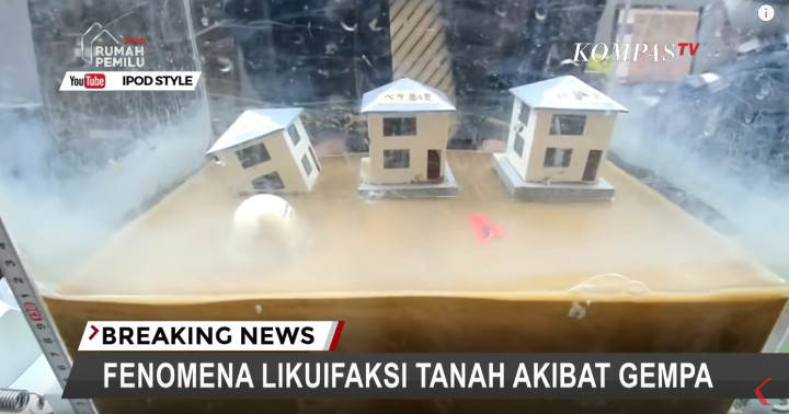
Example of Soil Liquefaction -
Mar 16, 2019; Example of Liquefaction - 2; , 2018
https://www.youtube.com/watch?v=jBrq1fPFJJA
https://www.youtube.com/watch?v=29ht6SSWQMs
I
WAS IN A 7.3 MAGNITUDE EARTHQUAKE & HOW YOU CAN HELP SAVE EBISU
CIRCUIT! M 7.3 Earthquake hits Japan off Fukushima, big after shock
13/2/2021.
https://www.youtube.com/watch?v=lR-pVGiMiTY
https://www.youtube.com/watch?v=lmUi6uWPSgg
Massive
landslides caught on camera. Массивные оползни, заснятые на камеру
(только несколько десятков из тысяч оползней). 2020-2021
https://www.youtube.com/watch?v=li8ITs7VTfw
https://www.youtube.com/watch?v=cH9r48RBYCY
https://www.youtube.com/watch?v=WlZHTcX3KiE
https://www.youtube.com/watch?v=Xke1uYC5lxA
Epic Crazy Moments of
Landslides Around the World Caught on Camera. Dec 16, 2020
https://www.youtube.com/watch?v=pBbamI04QGA
https://www.youtube.com/watch?v=wkV9DEKfYCw
https://www.youtube.com/watch?v=M5Zy1n9EjJw
https://www.youtube.com/watch?v=OgsBfLbyup0
Landslides caught on camera
ดินถล่มหนักที่ Japan,USA, China, Myanmar and India. Dec 9, 2020
https://www.youtube.com/watch?v=rUsOXRXfqhA&pbjreload=101
https://www.youtube.com/watch?v=cXrUAYwJBb8

Необъяснимое
Нечто Началось по
Всему Миру! Топ 10. Mar 2, 2021
https://www.youtube.com/watch?v=E4Ai_2gvG6k
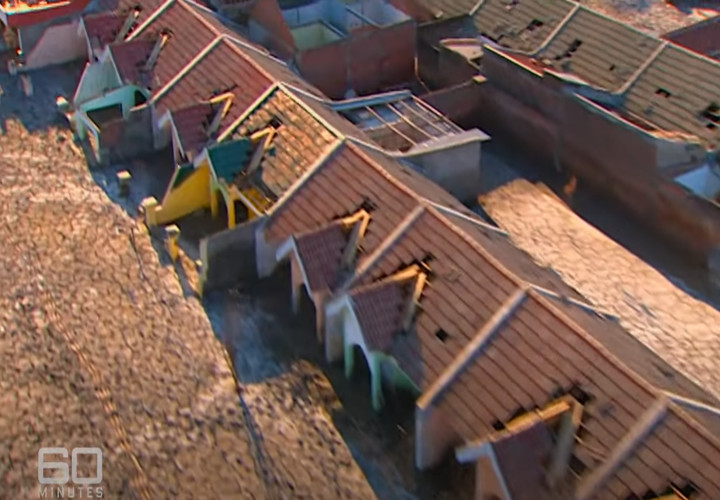
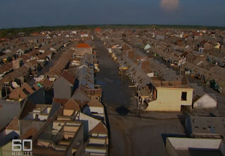
Indonesia
Liquefaction: 'The Ground Was Swirling'. Homes swallowed up in 'a wave
of mud' as Indonesia earthquake liquefied the soil. How the Indonesia
Earthquake Made Soil Flow Like Water (also in islands of Phillippines
and Japan). Tsunami floods into Indonesian city in terrifying new
footage. New footage shows people running away as a devastating tsunami
struck Indonesia's coastal city of Palu. About 5,000 people are still
missing or feared dead. Those searching the ruins of villages fear
thousands may have been swallowed up by the ground when the earthquake
caused liquefaction, causing the solid surface of the ground to turn to
liquid, engulfing homes in the mud. Oct 10, 2018.
https://www.youtube.com/watch?v=J_egBKj1W08
https://www.youtube.com/watch?v=FVqg8QagMjM
https://www.youtube.com/watch?v=0PoSTUr9nik
On
26 December 2004 the third-largest earthquake ever recorded struck the
coast of Sumatra, Indonesia, with a magnitude of 9.1. It generated the
deadliest tsunami in history--and one of the deadliest natural
disasters--killing nearly 228,000 people in 14 countries. Indonesia
lies above a tectonic plate boundary called a “subduction
zone” where
the Indo-Australian Plate grinds beneath the Eurasian Plate. Subduction
zones can produce megathrust earthquakes with large vertical seafloor
motions that cause devastating tsunamis such as the one in 2004. This
type of plate boundary can also give rise to volcanoes, and Indonesia
is home to many well-known active volcanoes, such as Krakatoa, which
can also generate tsunamis with their eruption and collapse. This
animation covers the 15 year period since the devastating earthquake
and tsunami of 2004. It begins with a map of plate boundaries, showing
the complexity of the region, and highlighting the sources of two
recent, unusual tsunamis: the Palu Fault that generated a deadly local
tsunami from a sideways-moving strike-slip earthquake (and possibly
landslides) within a narrow inlet, and the Anak Krakatau volcano
(within Krakatoa’s caldera) that collapsed during an eruption
to
produce another locally devastating tsunami.
Japan Quake Caused
Surprisingly Severe Soil Collapse. April 18, 2011
https://www.livescience.com/13765-japan-earthquake-soil-liquefaction.html
https://www.livescience.com/30320-worlds-biggest-earthquakes-110412.html
The
scale of Japan's March 11 earthquake and tsunami wasn't the only thing
that surprised geologists. The soil sank nearly 3 feet at this water
purification plant that serves 19,000 people, breaking pipes and
flooding underground structures. The 9.0 earthquake in Japan
— the
fourth most powerful quake ever recorded — also caused an
unusually
severe and widespread shift in soil through liquefaction, a new study
suggests. Near coastlines, harbors and rivers, earthquakes can make the
wet, sandy soil jiggle, turning it temporarily from a solid to a liquid
state, a process known as liquefaction. Heavy sand and rock sinks,
while water and lighter sand bubble to the surface. The slurry spreads,
often toward the water, and the surface shifts. Japan's liquefaction
occurred over hundreds of miles, surprising even experienced engineers
who are accustomed to seeing disaster sites, including from the recent
earthquakes in Chile and New Zealand.
The study raises questions about
whether existing building codes in other vulnerable locations can
enable structures to withstand massive liquefaction, including in areas
of Oregon (that explains many recent events in Portland), Washington
and California. "We've seen localized examples of
soil liquefaction as extreme as this before, but the distance and
extent of damage in Japan were unusually severe," said Scott Ashford, a
study team member from Oregon State University.
Portland: City Of Homeless Tents And Boarded Up Buildings. Mar 27, 2021
https://www.youtube.com/watch?v=SHlTID94eVQ
"Entire
structures
were tilted and sinking into the sediments, even while they remained
intact," said Ashford, who is based in Corvallis, Ore. "The shifts in
soil destroyed water, sewer and gas pipelines, crippling the utilities
and infrastructure these communities need to function. We saw some
places that sank as much as 4 feet," or 1.2 meters. The duration of the
Japanese earthquake, about five minutes, could be the key to the
severity of the liquefaction and may force researchers to reconsider
the extent of liquefaction damage possible.
"With such a
long-lasting earthquake, we saw how structures that might have been
okay after 30 seconds just continued to sink and tilt as the shaking
continued for several more minutes," Ashford said. "And it was clear
that younger sediments, and especially areas built on recently filled
ground, are much more vulnerable. An event almost exactly like Japan's
is expected in the Pacific Northwest from the Cascadia Subduction Zone,
and the new findings make it clear that liquefaction will be a critical
issue in the young soils there. "Young" sediments, in geologic terms,
are those deposited within the past 10,000 years or so. In Oregon, for
instance, that describes much of downtown Portland, the Portland
International Airport, nearby industrial facilities and other cities
and parts of the Willamette Valley. About 1,100 bridges in Oregon are
at risk from an earthquake on the Cascadia Subduction Zone, according
to the Oregon Department of Transportation. Fewer than 15 percent of
them have been retrofitted to prevent collapse. Some damage may be
reduced or prevented by different construction techniques or
retrofitting, Ashford said. But another reasonable goal is to at least
anticipate the damage — to know what will probably be
destroyed, make
contingency plans for what will be needed to implement repairs, and
design ways to help protect and care for residents until services can
be restored, the researchers say. The world's first recorded magnitude
9.0 earthquake struck off the east coast of Kamchatka in 1952. The
quake generated a 43-foot tsunami (13 m) locally. The tsunami rocked
Crescent City, Calif., which was also hit hard by the recent Japan
earthquake.
In Hawaii, property damage was
estimated at up to $1
million USD. The waves tossed boats onto the beach, caused houses to
collide, destroyed piers, scoured beaches and moved road pavement.
Kamchatka has a rumbling past and many active volcanoes. It was also
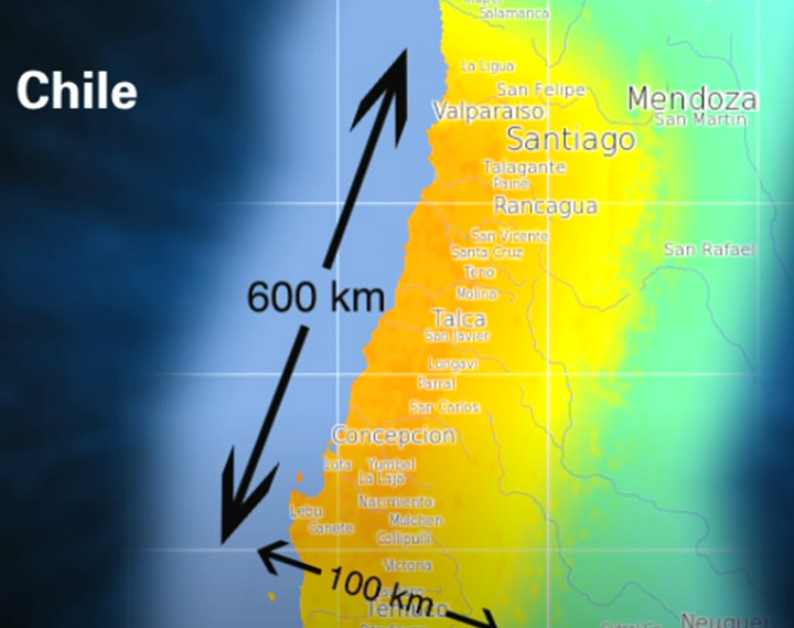
hit by an 8.5 magnitude quake in 1923. Chile, 1960 - Magnitude 9.5
earthquake-1960.
What
is liquefaction?
https://www.usgs.gov/faqs/what-liquefaction?qt-news_science_products=0#qt-news_science_products
Liquefaction
takes place when loosely packed, water-logged sediments at or near the
ground surface lose their strength in response to strong ground
shaking. Liquefaction occurring beneath buildings and other structures
can cause major damage during earthquakes. For example, the 1964
Niigata earthquake caused widespread liquefaction in Niigata, Japan
which destroyed many buildings. Also, during the 1989 Loma Prieta,
California earthquake, liquefaction of the soils and debris used to
fill in a lagoon caused major subsidence, fracturing, and horizontal
sliding of the ground surface in the Marina district in San Francisco.
Wikipedia.
Soil liquefaction occurs when a saturated or partially saturated soil
substantially loses strength and stiffness in response to an applied
stress such as shaking during an earthquake or other sudden change in
stress condition, in which material, that is ordinarily a solid,
behaves like a liquid. Liquefaction takes place when loosely packed,
water-logged sediments at or near the ground surface lose their
strength in response to strong ground shaking...For example, the 1964
Niigata earthquake caused widespread liquefaction in Niigata, Japan,
which destroyed many buildings. In addition, liquefaction may also
cause landslides. For example, during the Alaska earthquake of 1964,
the liquefaction of a sandy layer of soft clay beneath Turnagain
Heights, a suburb of Anchorage, caused a landslide in the mass of
ground above that destroyed approximately 75 homes and disrupted
utilities.
Землетрясение
в Индонезии 7.7, земля от тряски превращается в грязную жижу с камнями
и
поглощает строения, дороги, людей и скот, 1 октябрь 2018.
From
constant shaking Earth turns its Crustinto
liquid mud with stones and swallows
whatever is on the surface.
It's
going to happen everywhere.
Indonesia Earthquake 7.7, Oct 1, 2018.
https://www.youtube.com/watch?v=o4r7aLdRoEE
https://www.youtube.com/watch?v=tSDJ7NMlH7A
https://www.youtube.com/watch?v=Wnk7VVIUJFg
Liquefaction
and the Mud Flood. Oct 1, 2018. Looking at Liquefaction and how this
phenomena ties into the Mud Flood...
https://www.youtube.com/watch?v=YvTbdaStw_g
Soil
liquefaction due to earthquake.
https://www.youtube.com/watch?v=tW1iUAAMZZU
Report
cites "liquefaction",
as key to much of Japanese earthquake damage. April 18, 2011
https://today.oregonstate.edu/archives/2011/apr/report-cites-%E2%80%9Cliquefaction%E2%80%9D-key-much-japanese-earthquake-damage
CORVALLIS,
Ore. - The massive subduction zone earthquake in Japan caused a
significant level of soil "liquefaction" that has surprised researchers
with its widespread severity, a new analysis shows. The findings also
raise questions about whether existing building codes and engineering
technologies are adequately accounting for this phenomenon in other
vulnerable locations, which in the U.S. include Portland, Ore., parts
of the Willamette Valley and other areas of Oregon, Washington and
California. A preliminary report about some of the damage in Japan has
just been concluded by the Geotechnical Extreme Events Reconnaissance,
or GEER advance team, in work supported by the National Science
Foundation. The broad geographic extent of the liquefaction over
hundreds of miles was daunting to experienced engineers who are
accustomed to seeing disaster sites, including the recent earthquakes
in Chile and New Zealand. "We've seen localized examples of soil
liquefaction as extreme as this before, but the distance and extent of
damage in Japan were unusually severe," said Scott Ashford, a professor
of geotechnical engineering at Oregon State University and a member of
this research team. "Entire structures were tilted and sinking into the
sediments, even while they remained intact," Ashford said. "The shifts
in soil destroyed water, sewer and gas pipelines, crippling the
utilities and infrastructure these communities need to function. We saw
some places that sank as much as four feet." Some degree of soil
liquefaction is common in almost any major earthquake. It's a
phenomenon in which saturated soils, particularly recent sediments,
sand, gravel or fill, can lose much of their strength and flow during
an earthquake. This can allow structures to shift or sink and
significantly magnify the structural damage produced by the shaking
itself. But most earthquakes are much shorter than the recent event in
Japan, Ashford said. The length of the Japanese earthquake, as much as
five minutes, may force researchers to reconsider the extent of
liquefaction damage possible in situations such as this. "With such a
long-lasting earthquake, we saw how structures that might have been
okay after 30 seconds just continued to sink and tilt as the shaking
continued for several more minutes," he said. "And it was clear that
younger sediments, and especially areas built on recently filled
ground, are much more vulnerable." The data provided by analyzing the
Japanese earthquake, researchers said, should make it possible to
improve the understanding of this soil phenomenon and better prepare
for it in the future. Ashford said it was critical for the team to
collect the information quickly, before damage was removed in the
recovery efforts. "There's no doubt that we'll learn things from what
happened in Japan that will help us to mitigate risks in other similar
events," Ashford said. "Future construction in some places may make
more use of techniques known to reduce liquefaction, such as better
compaction to make soils dense, or use of reinforcing stone columns."
The massive subduction zone earthquakes capable of this type of
shaking, which are the most powerful in the world, don't happen
everywhere, even in other regions such as Southern California that face
seismic risks. But an event almost exactly like that is expected in the
Pacific Northwest from the Cascadia Subduction Zone, and the new
findings make it clear that liquefaction will be a critical issue
there. Many parts of that region, from northern California to British
Columbia, have younger soils vulnerable to liquefaction - on the coast,
near river deposits or in areas with filled ground. The "young"
sediments, in geologic terms, may be those deposited within the past
10,000 years or more. In Oregon, for instance, that describes much of
downtown Portland, the Portland International Airport, nearby
industrial facilities and other cities and parts of the Willamette
Valley. Anything near a river and old flood plains is a suspect, and
the Oregon Department of Transportation has already concluded that
1,100 bridges in the state are at risk from an earthquake on the
Cascadia Subduction Zone. Fewer than 15 percent of them have been
retrofitted to prevent collapse. "Buildings that are built on soils
vulnerable to liquefaction not only tend to sink or tilt during an
earthquake, but slide downhill if there's any slope, like towards a
nearby river," Ashford said. "This is called lateral spreading. In
Portland we might expect this sideways sliding of more than four feet
in some cases, more than enough to tear apart buildings and buried
pipelines." Some damage may be reduced or prevented by different
construction techniques or retrofitting, Ashford said. But another
reasonable goal is to at least anticipate the damage - to know what
will probably be destroyed, make contingency plans for what will be
needed to implement repairs, and design ways to help protect and care
for residents until services can be restored. Small armies of utility
crews are already at work in Japan on such tasks, Ashford said. There
have been estimates of $300 billion in damage. The recent survey in
Japan identified areas as far away as Tokyo Bay that had
liquefaction-induced ground failures. The magnitude of settlement and
tilt was "larger than previously observed for such light structures,"
the researchers wrote in their report. Impacts and deformation were
erratic, often varying significantly from one street to the next. Port
facilities along the coast faced major liquefaction damage. Strong
Japanese construction standards helped prevent many buildings from
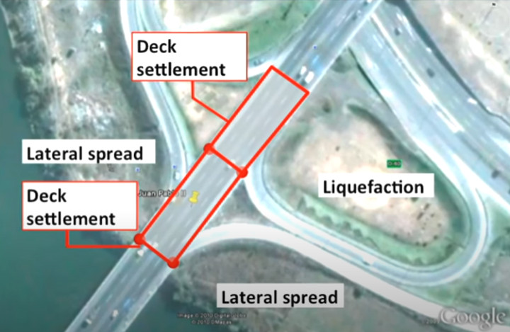
collapse - even as they tilted and sank into the ground. Liquefaction in New Zealand,
Christchurch earthquake in 2011.
Комбинация
песчанных бурь и
наводнений одновременно сейчас не только в арабских странах, но и по
всему миру.
"STEVE" SIGHTED IN CALGARY, ALBERTA AND BRITISH COLUMBIA at different
days.
Video of it is on : http://www.spaceweather.com/
STEVE,
video - IN MOTION: On May 19th and 20th, a solar wind stream hit
Earth's magnetic field. The impact summoned "Steve"--a mysterious form
of filamentary aurora that researchers do not fully understand. "I saw
'Steve' through the window even though the lights were still on in the
house, so it must have been quite bright," reports Matthew Wheeler of
Robson Valley, BC, Canada. Grabbing his camera, he rushed outside for a
better view, and captured a rare movie of Steve in motion:"I have seen
Steve here a few times in the past decades," says Wheeler. "This was a
dramatic apparition, especially overhead where fine fingers of color
moved very fast almost at right angles to Steve, quite finely detailed
at times. The 10 second exposures I stitched together to make the
animation don't do it justice."
For years, northern sky watchers
have occasionally spotted a mysterious ribbon of purple light dancing
among the aurora borealis. It was widely called a "proton arc" until
researchers pointed out that protons probably had nothing to do with
it. So members of the Alberta Aurora Chasers group gave it a new name:
"Steve." Recent widespread reporting about Steve has led to even more
sightings--and indeed he appeared just this week over Calgary:"Steve
hung out with me for about 15 minutes on May 17th," reports
photographer Harlan Thomas, who witnessed a spectacular display of
auroras over Twisted Ponds. The lights appeared as Earth moved through
a stream of fast-moving solar wind that briefly interacted with our
planet two days ago. Steve is still a mystery. No one fully understands
the underlying physics of the ribbon. However, one of the
European Space Agency's SWARM satellites recently flew overhead while
Steve was active, providing some clues. "As the satellite flew straight
though Steve, data from the electric field instrument showed very clear
changes" reports Eric Donovan from the University of Calgary. "The
temperature 300 km above Earth's surface jumped by 3000°C and
the data
revealed a 25 km-wide ribbon of gas flowing westwards at about 6 km/s
compared to a speed of about 10 m/s either side of the ribbon."
http://www.spaceweather.com/
Стив - новое атмосферное явление!
(Что-то
здесь не так: в английской статье пишется что это явление -
не
новое. Я также вижу Белую Полосу на фото, а не фиолетово-зелёную.
Похоже на Белую Солнечную Плазменную Энергию Баланса, раз температура
доходит до +3000С. И хорошо что тянется на тыщи км, быстрее всё
растает! ЛМ)
http://earth-chronicles.ru/news/2017-04-22-103693
Встречайте
Стива — новое атмосферное явление! Стив настолько странный,
что до сих
пор не имеет официального научного описания, поэтому и имя у него
временное. Благодаря любителям полярных сияний и ученых, изучающих
атмосферу, мы узнали о Стиве больше, но осталось еще много вопросов.
Восхитительный феномен был впервые задокументирован группой
«Охотники
за аврорами Альберты» на «Фейсбуке». С
тех пор о Стиве сообщили еще
более 50 раз. Эта лента из фиолетовых и зеленых огней не похожа на
любое другое полярное сияние, и мы до сих пор не знаем, почему она
образуется. Работа энтузиастов привлекла внимание ученых НАСА, ЕКА и
Университета Калгари (Канада), которые активно пытаются выяснить, что
на самом деле представляет из себя этот неустойчивый объект. Стив
— это
арка шириной 25–30 км, которая тянется на сотни, тысячи
километров с
востока на запад. Феномен может оставаться на небе час или дольше, и
имеет сезонный характер, исчезая с октября по февраль. Стив обычно
состоит из фиолетовых оттенков и часто сопровождается зелеными
кратковременными образованиями в виде частокола. Явление возникает в
Северном полушарии вдоль тех же широт, что и Калгари в Альберте.
Недавно один из спутников Swarm пролетел прямо через Стива. На высоте
300 км датчики зафиксировали повышение температуры на 3 тысячи градусов
Цельсия, а данные показали 25-километровую ленту газа, плывущую на
запад на скорости 6–10 км/с.
SOLAR RADIO BURSTS (highly recommended listening)
(After
listening to this audio recording, I realised, that this exact sound I
hear with my ears most of the time, day and night, and without a
radio-telescope! It doesn't remind me a hiss, but the sound of rain or
a waterfall, sometimes becoming unbearably loud! And maybe someone else
is hearing it too? LM)
http://www.spaceweather.com/
Yesterday's
M4.4 solar flare from sunspot AR2644 flare caused a shortwave radio
blackout. It also produced the opposite--a loud burst of radio static.
In rural New Mexico, amateur radio astronomer Thomas Ashcraft recorded
the hiss and crackle emerging from the loudspeaker of his receiver.
Click to listen to this audio recording.
Арктический форт.
Специальный репортаж Дмитрия Кодаченко. Россия разместила военные базы
по своей границе на островах и архипелагах Северного Ледовитого океана.
Уникальные сооружения больше напоминают космические объекты. В самый
холодный месяц прямо по льду моря Лаптевых многотонная техника прошла
около 2 тысяч километров, чтобы доказать свою безотказность в самых
невыносимых условиях. 22, 2017
https://www.youtube.com/watch?v=67A3diVCfUM
Арктический форт - video
http://earth-chronicles.ru/news/2017-04-24-103730
Россия
разместила военные базы по своей границе на островах и архипелагах
Северного Ледовитого океана. Уникальные сооружения больше напоминают
космические объекты. В самый холодный месяц прямо по льду моря Лаптевых
многотонная техника прошла около 2 тысяч километров, чтобы доказать
свою безотказность в самых невыносимых условиях.

Australia. View of flooded area of
Sydney seen from a helicopter. An
aerial view of the flooded area of western Sydney as seen from the
7NEWS helicopter - includes images of the Nepean River, Warragamba Dam,
Penrith, Yarramundi, Agnes Waters, North Richmond, Richmond Lowlands,
Conwallis, Windsor, Pitt Town Bottoms and Wilberforce. Floods: ADF
troops called in, BOM weather update, Kempsey on edge, 9 News
Australia. 22-23 March, 2021
https://www.youtube.com/watch?v=_hUxqcQxuZw
https://www.youtube.com/watch?v=D_SaxkDArFQ
https://www.youtube.com/watch?v=pMMrDRZX_Ss
https://www.youtube.com/watch?v=uqPtnOFkxQs